
Cart 0 Product Products (empty)
No products
To be determined Shipping
0,00 € Total
Product successfully added to your shopping cart
Quantity
Total
There are 0 items in your cart. There is 1 item in your cart.
Total products
Total shipping To be determined
Total
Menu
- Home
- 1/35 & 1/32
- Publicity panels
- Propaganda Posters
- WW I
- Spanish Civil War
- WW II E.T.O.
- WW II P.T.O.
- WW II Ostfront
- WW II Afrika
- Korea
- Vietnam
- Other Conflicts
- Publicity Posters
- Items on decal
- Cardboard boxes
- Roadsigns, directional & traffic signs
- Carpets and tapestry
- Vintage wallpaper
- Stained glass
- Curtains
- Zombies
- Miscelaneous
- Uniform insignia
- Building accessories
- Flags on tissue
- Flags on decal
- Maps, magazines
- Stencils
- Bathroom
- Bedroom
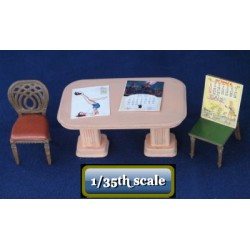
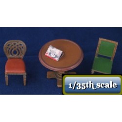
- Living room
- Kitchen
- Modern furniture
- Garden
- Office
- Furniture various
- Animals
- Ammo boxes
- Bags & barrels
- Cargo
- Nautical Items
- Vintage wheels
- Military : Allies
- Military : German
- Military : Italian
- Military : Russian
- Military : others
- Nature
- Oil drums & Jerry cans
- Garage & workshop
- Personal gear
- Wicker baskets
- Clothing
- Weapons
- Toys
- Music
- Construction Urban
- Construction Rural
- Construction Cemetery
- Construction roadside
- Construction modern
- Fountains & statues
- Paintings & Picture frames
- Construction : fortifications
- Construction : shops & houses
- Food
- Cooking utensils
- Lamps & lights
- Religious items
- Various
- Bases & soccles
- Figurines
- Figurines Aurora
- 1/48 & 1/50
- Publicity panels
- Propaganda Posters
- Publicity Posters
- Items on decal
- Cardboard boxes
- Roadsigns & traffic signs
- Carpets & tapestries
- Vintage wallpaper
- Stained glass
- Miscelaneous
- Building accessories
- Flags on decal
- Maps, newspapers
- Bathroom
- Bedroom
- Living room
- Kitchen
- Modern furniture
- Garden
- Office
- Bags, barrels
- Nature
- Oildrums, jerrycans
- Garage, workshop
- Construction Urban
- Construction Rural
- Construction Cemetary
- Airfield accessories
- Food
- Miscelaneous
- Figurines
- 1/72 & 1/87
- Publicity panels
- Propaganda Posters
- Publicity Posters
- Items decal
- Cardboard boxes
- Roadsigns & traffic signs
- Carpets, tapestries
- Vintage wallpaper
- Stained glass
- Miscelaneous
- Building accessories
- Flags decal
- Maps magazines
- Bathroom
- Bedroom
- Living room
- Kitchen
- Modern furniture
- Garden
- Office
- Animals
- Bag,Barrel,Basket
- Cargo
- NAUTICAL ITEMS
- Military ornaments German
- Nature
- Oildrums, jerrycans
- Garage & workshop
- Music
- Construction Urban
- Construction rural
- Construction cemetary
- Construction roadside
- Construction modern
- Fountains and statues
- Airfield accessories
- Paintings & Picture frames
- Food
- Religious items
- Figurines
- 1/16 & 1/18
- 1/24 & 1/25
- Tools & other scales
- WW I
- Dollhouse
- 1/350
- 1/144 articles
- 1/43
- multiscale products
- 1/6
- XXS
- German decals
- 1/144
- Tools
- Airbrush
- Flags
- Patches
- 1/35 & 1/32
- 1/35 & 1/32
- Publicity panels
- Propaganda Posters
- WW I
- Spanish Civil War
- WW II E.T.O.
- WW II P.T.O.
- WW II Ostfront
- WW II Afrika
- Korea
- Vietnam
- Other Conflicts
- Publicity Posters
- Items on decal
- Cardboard boxes
- Roadsigns, directional & traffic signs
- Carpets and tapestry
- Vintage wallpaper
- Stained glass
- Curtains
- Zombies
- Miscelaneous
- Uniform insignia
- Building accessories
- Flags on tissue
- Flags on decal
- Maps, magazines
- Stencils
- Bathroom
- Bedroom
- Living room
- Kitchen
- Modern furniture
- Garden
- Office
- Furniture various
- Animals
- Ammo boxes
- Bags & barrels
- Cargo
- Nautical Items
- Vintage wheels
- Military : Allies
- Military : German
- Military : Italian
- Military : Russian
- Military : others
- Nature
- Oil drums & Jerry cans
- Garage & workshop
- Personal gear
- Wicker baskets
- Clothing
- Weapons
- Toys
- Music
- Construction Urban
- Construction Rural
- Construction Cemetery
- Construction roadside
- Construction modern
- Fountains & statues
- Paintings & Picture frames
- Construction : fortifications
- Construction : shops & houses
- Food
- Cooking utensils
- Lamps & lights
- Religious items
- Various
- Bases & soccles
- Figurines
- Figurines Aurora

- 1/48 & 1/50
- Publicity panels
- Propaganda Posters
- Publicity Posters
- Items on decal
- Cardboard boxes
- Roadsigns & traffic signs
- Carpets & tapestries
- Vintage wallpaper
- Stained glass
- Miscelaneous
- Building accessories
- Flags on decal
- Maps, newspapers
- Bathroom
- Bedroom
- Living room
- Kitchen
- Modern furniture
- Garden
- Office
- Bags, barrels
- Nature
- Oildrums, jerrycans
- Garage, workshop
- Construction Urban
- Construction Rural
- Construction Cemetary
- Airfield accessories
- Food
- Miscelaneous
- Figurines

- 1/72 & 1/87
- Publicity panels
- Propaganda Posters
- Publicity Posters
- Items decal
- Cardboard boxes
- Roadsigns & traffic signs
- Carpets, tapestries
- Vintage wallpaper
- Stained glass
- Miscelaneous
- Building accessories
- Flags decal
- Maps magazines
- Bathroom
- Bedroom
- Living room
- Kitchen
- Modern furniture
- Garden
- Office
- Animals
- Bag,Barrel,Basket
- Cargo
- NAUTICAL ITEMS
- Military ornaments German
- Nature
- Oildrums, jerrycans
- Garage & workshop
- Music
- Construction Urban
- Construction rural
- Construction cemetary
- Construction roadside
- Construction modern
- Fountains and statues
- Airfield accessories
- Paintings & Picture frames
- Food
- Religious items
- Figurines

- 1/16 & 1/18
- 1/24 & 1/25
- 1/350
- 1/6
- 1/43
- 1/144
- WW I
- WW II E.T.O.
- WW II P.T.O.
- WW II Ostfront
- WW II Afrika
- Korea
- Vietnam
- XXS
- Dollhouse
- multiscale products
- Tutorials
- Zombies
- German decals
- Tools
- Airbrush
- Flags
- Patches
- Figurines Aurora


More info
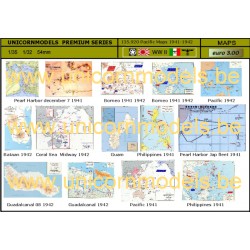
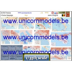
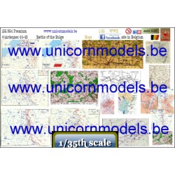
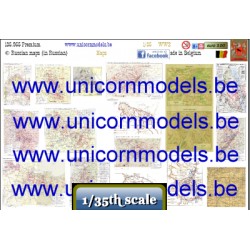
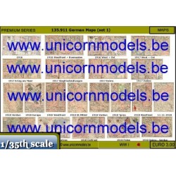
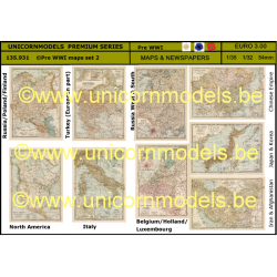
Maps and trenchmaps from WW I : a.o. Belgium, France, Verdun, Somme, Ypres, Passchendaele, Tyne Cot,..., all in high definition laser print.
Dimensions : aprox. 175 x 110 mm.
Reviews
No customer reviews for the moment.

29 other products in the same category:
-

Maps Normandy
3,00 €
-
Maps...
3,00 €
-
Maps...
3,00 €
-
Maps Ardennes
3,00 €
-
Russian maps
3,00 €
-

Desert war...
3,00 €
-

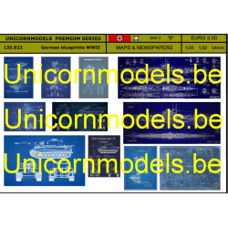
German maps...
3,00 €
-
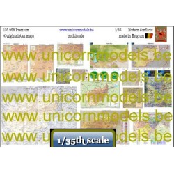
Afghanistan...
3,00 €
-
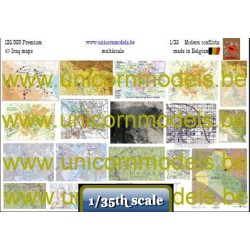
Iraq maps
3,00 €
-

Maps Vietnam
3,00 €
-
WW I German...
3,00 €
-
Esquire &...
3,00 €
-
Yank...
3,00 €
-
US &...
3,00 €
-
German...
3,00 €
-
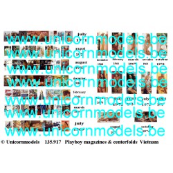
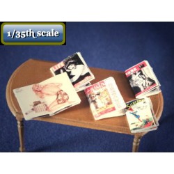
Playboy...
3,00 €
-
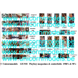
Playboy...
3,00 €
-
Maps...
3,00 €
-
Desert war...
3,00 €
-
German...
3,00 €
-
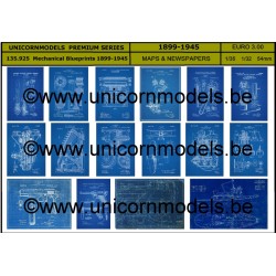
Mechanical...
3,00 €
-
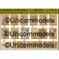
Mechanical...
3,00 €
-
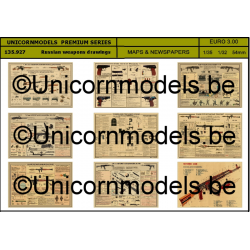
Russian...
3,00 €
-
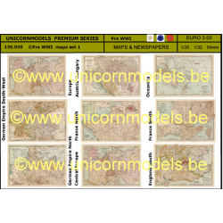
Pre WWI...
3,00 €
-
Pre WWI...
3,00 €
-

Pin-up...
3,00 €
-

Pin-up...
3,00 €
-

Pin-up...
3,00 €
-
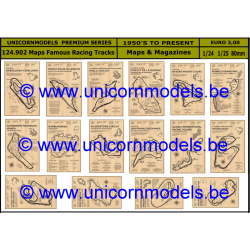
Maps Famous...
3,00 €